
The Central Board of Secondary Education has released the CBSE Class 12 Geography Additional Practice Question Paper 2023-24 with the marking scheme at its official website i.e., https://cbseacademic.nic.in/. The students preparing to appear in the CBSE Class 12 Board Exams for the session 2023-24 must carefully go through the Class 12 Geography Additional Practice Question Paper and practice all the questions properly as it will help them understand and get familiarized with the newly updated format of the actual CBSE Class 12 Geography exam 2023-24. Here we have discussed the whole CBSE Class 12 Geography Additional Practice Question Paper 2023-23 below in the article.
CBSE Class 12 Geography Additional Practice Question Paper 2023-24
The Central Board of Secondary Education has now released the Class 12th subject-wise practice papers according to the updated format which comprises the entire syllabus of CLASS 12. One of the most interesting facts about this updated format of the Class 12 Board pattern is that the question paper will carry 50% of the competitive questions. The CBSE Class 12 Additional Practice Papers 2023-24 provides an overview of the actual exam pattern, including the number of sections, number of questions, types of questions (Multiple choice, Short answer, Long answer), time duration, and overall structure of the actual examination. The CBSE Class 12 Geography Additional question paper contains 30 questions. And all the questions are compulsory.
- The Class 12th Geography question paper is divided into five sections. Sections -A, B, C, D and E.
- Section A: Questions 01 to 17 are multiple-choice questions carrying 01 marks.
- Section B: Questions 18 and 19 are Source Based Questions carrying 03 marks each.
- Section C: Questions 20 to 23 are Short Answer Type Questions carrying 03 marks each. These questions are to be answered in 80 to 100 words.
- Section D: Questions 24 to 28 are Long Answer Type Questions carrying 05 marks each. These answers are to be answered in 120 to 100 words.
- Section E: Question 29 and Question 30 are map-based questions.
Class 12 Geography Additional Practice Question paper 2023-24 (CBSE) Pdf
The students can download the Class 12 Geography Additional Practice Question Paper 2023-24 pdf along with the answers and marking scheme. The students appearing in the CBSE Class 12th exams must practice these Additional Practice Question Papers as practicing these practice papers will help the students familiarize themselves with the latest Board Exam pattern and the types of questions that can be asked in the main exam.
| CBSE Class 12 Geography Additional Practice Question Paper 2023-24 pdf | |
| Additional Practice Question Paper pdf | Solution pdf |
| Class 12 Geography Practice Question Paper Pdf Link | Solution Link |
Geography Additional Practice Question Paper 2023-24
Here we have briefly discussed all the questions of the CBSE Class 12 Additional Practice Question Paper 2023-24 with their respective answers.
Section A – Multiple Choice Questions
Q1: There are two statements given below, marked as Assertion (A) and Reason (R). Read the statements and choose the correct option.
Assertion (A): There is a positive correlation between per capita income and human development.
Reason (R): Higher-income individuals are comparatively more motivated, which leads to better life choices.
(a) A is true but R is false.
(b) A is false but R is true.
(c) Both A and R are true and R explains A.
(d) Both A and R are true but R does not explain A.
Answer: (a) A is true but R is false.
Q2: The following are events on the right side of the table that are associated with the demographic transition theory. Match them with the different stages of the transition stage listed on the left side.
| Stages of democratic transition. | events related to each other | ||
| 1 | Transition from stage 1 to stage 2 | P | The death rate declined due to improved healthcare. |
| 2 | Transition from Stage 2 to Stage 3 | Q | Population growth increases. |
| 3 | Transition from stage 3 to stage 4 | R | Population growth slows down. |
| 4 | Stage 4 | S | The fertility rate declines due to increased access to education and contraception. |
(a) 1 – R, 2 – Q, 3 – S, 4 – P
(b) 1- Q, 2 – S, 3 – R, 4 – P
(c) 1 – P, 2 – Q, 3 – S, 4 – R
(d) 1 – Q, 2 – S, 3 – P, 4 – R
Answer: (c) 1 – P, 2 – Q, 3 – S, 4 – R
Q3. Read the following quote and answer the following question.
“Having the same currency, the eleven countries are likely to enlarge their mutual trade”
Which of the following regional trade blocks is the above information discussing?
(a) EU (European Union)
(b) OPEC (Oil and Petroleum Exporting Countries)
(c) NAFTA (North American Free Trade Association)
(d) ASEAN (Association of South East Asian Nations)
Answer: (a) EU (European Union)
Q4: Read the following statements and answer the question that follows.
Statement 1 – Increased cropping intensity has created more employment opportunities in the agricultural sector.
Statement 2 – Severe groundwater depletion over the years has adversely affected the cropping intensity in India.
Which of the following is correct?
(a) Only statement I is correct
(b) Only statement II is correct
(c) Both statements are true but not related to each other
(d) Both the statements are correct, and statement II correctly explains statement I.
Answer: (c) Both statements are true but not related to each other.
Q5: Given below are some indicators of the Human Development Index (HDI).
Which of these indicators are matched with their correct meanings on the right?
(a) P and Q
(b) Q and R
(c) R and S
(d) S and P
Answer: (c) R and S
Q6. Why is the work participation rate generally higher in underdeveloped or developing nations?
(a) Underdeveloped nations often rely heavily on labor-intensive industries, leading to a higher demand for the labor force.
(b) Underdeveloped nations have a higher population density, resulting in more people seeking employment opportunities.
(c) Developing nations have a greater emphasis on leisure and less inclination towards workforce participation.
(d) Developing nations have well-established social welfare programs that discourage workforce participation.
Answer: (a) Underdeveloped nations often rely heavily on labor-intensive industries, leading to a higher demand for the labor force.
Q7. Which economic policies should a nation adopt to increase its share in the international market?
P) imposing high import tariffs to protect domestic industries
Q) focusing on bilateral trade agreements with neighboring countries
R) encouraging export-oriented manufacturing in various economic zones
S) reducing trade quotas and opening up the economy to foreign investments
(a) P and Q
(b) Q and R
(c) R and S
(d) P and S
Answer: . (c) R and S
Q8. XYZ is a non-profit organization that works in the field of assessment research and educational technology. It is involved in conducting research related to educational assessments, developing educational technology tools, and providing solutions to improve the quality of education and learning outcomes.
Which of the following operations should it take up to create an additional KPO (knowledge processing outsourcing)?
(a) Data entry and transcription services
(b) Manufacturing and production services
(c) Customer support and call center services
(d) Curriculum development and instructional design
Answer: . (d) Curriculum development and instructional design.
Q9. What kind of farming does the image given below DEFINITELY depict?
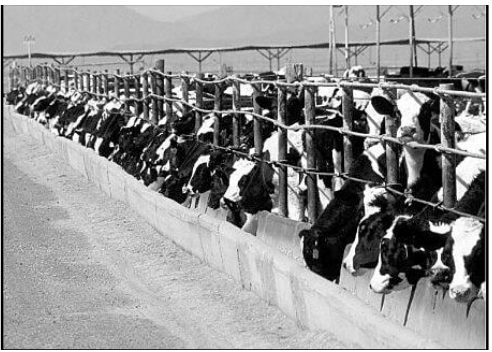
(a) market gardening
(b) collective farming
(c) factory farming
(d) truck farming
Answer: (c) factory farming.
Q10. Read the two statements given below and select the correct option.
S1: Roadways are one of the most widely used modes of transportation all across the world.
S2: Roadways offer the best last-mile connectivity for short distances.
(a) S1 is the cause of S2
(b) S2 is true but S1 is false.
(c) S2 is a contributing factor to S1.
(d) S1 and S2 are independent of each other.
Answer: (c) S2 is a contributing factor to S1.
Q11. Given below are the steps involved in the formation of crude petroleum.
(I) Sediment is subjected to heat and pressure over millions of years.
(II) Dead plants and animals are buried under layers of sediment.
(III) The hydrocarbons are trapped in porous rocks.
(IV) Crude petroleum is extracted from the rocks.
(V) The organic matter is converted into hydrocarbons.
Arrange these steps in the correct order of formation.
(a) II – I – V – III – IV
(b) II – V – I – III – IV
(c) I – II – III – V – IV
(d) I – III – II – IV – V
Answer: . (b) II – V – I – III – IV
Q12. A recent study by Eos News magazine observed that timely and efficient weather forecasting could greatly improve the benefits of rainwater harvesting, which can result in controlling urban floods to an extent.
Accordingly, how do rainwater harvesting methods help control urban flooding?
(a) by altering weather patterns and reducing the intensity of rainfall.
(b) by creating a barrier against floodwaters and protecting urban infrastructure.
(c) by diverting excess rainwater to nearby rivers and preventing floodwater accumulation.
(d) by creating additional storage capacity and reducing the pressure on stormwater drainage systems.
Answer: (d) by creating additional storage capacity and reducing the pressure on stormwater drainage systems.
Q13. Observe the following map of India with the North-South and East-West highway projects marked on it.
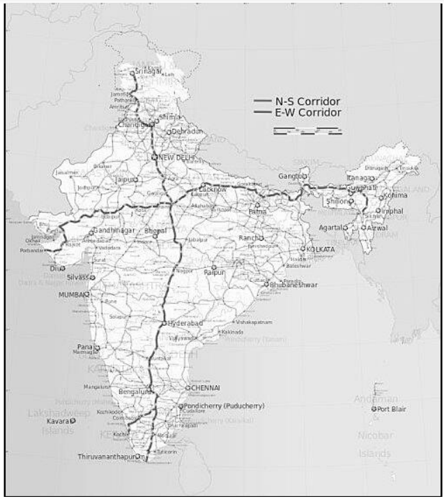
Accordingly, which of the following statements about these corridors is DEFINITELY correct?
(a) North-South and East-West corridors intersect in the national capital.
(b) Kochi is one of the terminal stations of the North-South corridor in the south.
(c) The East-West corridor connects the easternmost point to the westernmost point of India.
(d) The length of the East-West corridor exceeds the length of the North-South corridor.
Answer: (b) Kerala is one of the terminal states of the North-South corridor in the south.
Q14. ‘Subduction (sinking of land) in parts of Haryana, Punjab, and Delhi is as high as 7-12 cm a year. . . . Over time when the underlying aquifers (deep channels that store percolated water) aren’t recharged, they run dry and the layers of soil and rock above them start to sink . . . but a reversal is possible if aquifers are left to charge.’
Source (edited): The Hindu
Based on this information, what is the MOST LIKELY cause behind the issue highlighted in the news piece?
(a) excessive rainwater causing floods leading to soil erosion and land sinking.
(b) increased urbanization and construction activities leading to land sinking.
(c) natural geological processes causing land to sink in certain regions.
(d) extensive water extraction for irrigation use causing land sinking.
Answer: (d) extensive water extraction for irrigation use causing land sinking.
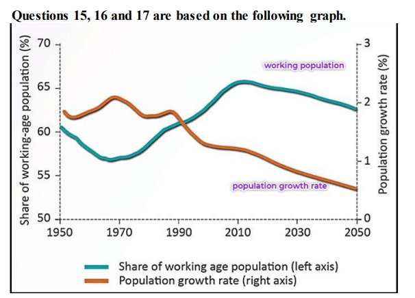
Q15. Which of the following can be inferred from the graph?
(a) the population is increasing fast but aging slowly.
(b) the population is increasing slowly but aging fast.
(c) the population is stagnant and aging fast.
(d) the population is increasing as well as aging slowly.
Answer: (b) the population is increasing slowly but aging fast.
Q16. Which of the following challenges are MOST LIKELY to arise soon due to, the trends depicted in the graph?
P: decreased investment in education and skill development
Q: decreased economic growth due to rising unemployment issues
R: increased strain on healthcare systems and social welfare programs
S: increased burden on the working-age population to support the elderly
(a) P and Q
(b) Q and R
(c) R and S
(d) P and S
Answer: (c) R and S.
Q17. If this situation exists in country X, which of the following should be encouraged by X to promote sustainable economic growth in all sectors?
(a) promoting open immigration policies to facilitate the entry of foreign workers.
(b) promoting technological advancements to automate tasks and increase productivity.
(c) implementing policies to increase the retirement age and reduce social security benefits.
(d) encouraging the emigration of elderly citizens to alleviate the strain on social welfare systems.
Answer: (a) promoting open immigration policies to facilitate the entry of foreign workers.
The following questions are for Visually Impaired Candidates only in lieu of Q. No. 15,16 and 17.
Q15.1. To calculate the population density of region X, which of the following factors will be directly or indirectly taken into account?
P: total number of people who moved (immigrated) into the region
Q: total number of people who moved out (emigrated) of the region
R: total number of people who died in the region in the given year
S: total number of people who were born in the region in the given year
(a) P and Q
(b) Q and R
(c) R and S
(d) P and S
Answer: (d) P and S
Q16.1. According to Malthusian theory, what would happen if an exponentially growing population exceeds its limit?
P: The population will stabilize at a sustainable level.
Q: The government will implement strict birth control measures.
R: The population will experience a decrease in their living standards.
S: The availability of resources will become insufficient to support the population.
(a) P and Q
(b) Q and R
(c) R and S
(d) P and S
Answer: (c) R and S
Q17.1. India recently outnumbered China in population growth.
Which of the following is MOST LIKELY the reason behind this growth?
(a) India’s GDP per capita is lower than China’s.
(b) India has a higher life expectancy than China.
(c) India’s fertility rate is still higher than China’s.
(d) India has a higher infant mortality rate than China.
Answer: (c) India’s fertility rate is still higher than China’s.
Section B
Q18. ‘A city’s space will only get scarcer and more stretched, and therefore a Smart City should prioritize more of its spaces for shared use than for a single individual. A Smart City should prioritize public spaces over private spaces. Sprawling individual houses in a city are more resource inefficient than community housing complexes.’
Source (edited): The Wire
a) What fundamental aim drives the mission mentioned above?
b) Discuss two ways to achieve resource efficiency in such Smart Cities as suggested in the excerpt.
Answer: (a) Aim
– The mission aims to advance cities that prioritize essential infrastructure, foster a clean and sustainable environment, and ensure a satisfactory quality of life for their residents.
(to be assessed as a whole)
(b) Suggestions
– The city’s administration should prioritize affordable and convenient public transportation over individual vehicles for increased resource efficiency.
– Public amenities like large libraries and open-to-all-all swimming pools should take precedence over exclusive private clubs, golf courses, etc.
– Accessible public parks and recreational spaces for all should take precedence over gated communities that restrict public entry.
– any other relevant point
(any two points to be assessed for two marks).
Q19. Observe the map of the region between North and South America given below and answer the questions that follow.
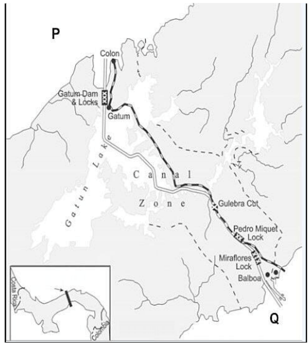
A) Identify the man-made waterway depicted in the image.
B) Name the water bodies marked as P and Q.
C) How does this waterway contribute to environmental preservation?
The following questions are for Visually Impaired Candidates ONLY in lieu of question no. 19.
A) Name the man-made waterway constructed by the U.S. government that divides North and South America.
B) Which two large bodies of water does this waterway connect?
C) Highlight how this waterway contributes to environmental preservation.
Answer: A) Panama Canal
B) P – Atlantic Ocean
Q – Pacific Ocean
C) It provides a shortcut route for maritime trade between the two oceans and thus helps to reduce emissions, fuel consumption, and carbon footprint.
– any other relevant point
(to be assessed as a whole)
Q20. ‘Human growth and human development are two terms that are often used interchangeably to express progress. However, the truth is that there is an enormous difference…’
Source (edited): tribuneindia
Explain two key differences between the terms mentioned above and justify the difference with a practical example.
OR
Q20. Bhutan, despite its smaller size and national income compared to India, ranks higher on the Human Development Index. Explain the possible reason behind this.
Answer: A) Panama Canal
B) Atlantic Ocean and Pacific Ocean
C) reduces emissions, fuel consumption, and carbon footprint by providing a crucial shortcut route for maritime trade.
Section C
Q21. ‘If development is not engendered, it is endangered.’
Source: HDR UNDP 1995
Explain this quote in the context of the Government of India’s initiative ‘Beti Bachao Beti Padhao Andolan’.
Answer: Growth
1. Growth is quantitative and value-neutral in nature.
2. Growth is a narrower concept that comprises a singular variable.
Development
1. Development is qualitative and positive in nature.
2. Development is a comprehensive and wider concept that comprises multiple variables.
Eg. If a country experiences a significant increase in its GDP, it indicates economic growth.
However, if the majority of the population continues to face poverty, lack of quality education,
inadequate healthcare, etc., then this growth is not accompanied by development.
– any other point/example
(to be assessed as a whole)
OR
Territory size and per capita income do not alone determine human development levels in nations.
– Smaller countries often outperform larger ones in terms of human development such as in the case of Bhutan performing better than its much larger neighbor, India.
– It is possible that Bhutan does better than India when it comes to income equality, quality of education and healthcare, environmental sustainability, gender equality, etc. which gets it a better rank.
– any other relevant point
(to be assessed as a whole)
Answer21. – The quote means that if development does not include the empowerment of women, it is not sustainable. This is because women play a vital role in society, and their contributions are essential for economic growth and social progress.
– The Government of India’s initiative ‘Beti Bachao Beti Padhao Andolan’ is a campaign to promote the education and well-being of girls. The campaign aims to address the declining sex ratio at birth in India, which is a result of the preference for sons over daughters.
– It is an important initiative as it addresses the root cause of gender inequality in India. By promoting the education and well-being of girls, the campaign is helping to ensure that women have the opportunity to contribute to society and that the resultant development is sustainable.
(to be assessed as a whole)
Q22. When attempting to create opportunities in nature through human modifications, what environmental considerations should individuals take into account to reduce adverse impacts?
Answer. Ecological Impact: Modifications should not harm or disrupt local ecosystems, biodiversity, or natural habitats. Consideration should be given to preserving or enhancing the natural environment.
Climate Change: Modifications should take into account the potential effects of climate change and aim to minimize carbon emissions, energy consumption, and other greenhouse gas emissions.
Resource Conservation: Sustainable use of resources should be prioritized to avoid excessive depletion or waste. This includes water conservation, efficient use of materials, and minimizing pollution or contamination.
Waste Management: Proper waste management practices should be implemented to reduce environmental pollution and ensure proper disposal or recycling of waste generated from modifications.
Environmental Regulations: Compliance with environmental laws and regulations is essential. Any modifications should align with applicable environmental standards and guidelines set by authorities.
– any other relevant consideration
(any five points to be assessed for five marks)
OR
Q22. Answer the following questions with respect to the evolution of Geography as a discipline:
a) In the 1970s, why was there discontentment with the quantitative revolution in Geography, which aimed to bring more scientific rigor and mathematical modeling to geographic research?
b) How did this discontentment influence the further approaches to the discipline in the years ahead? Explain the transition with an example.
Answer: (a) Neglect of qualitative approaches
The emphasis on quantitative analysis led to a neglect of qualitative methods which provide in-depth insights and contextual understanding, which many geographers felt were essential for capturing the complexities of human experiences and cultural dynamics.
Lack of critical and theoretical perspectives
The quantitative revolution was criticized for its limited attention to critical and theoretical frameworks and primary focus on empirical analysis and statistical techniques, overlooking the broader social, political, and economic contexts in which geographic processes occur.
– any other relevant point
(award one mark for each point)
Integration of Multiple Approaches: Over time, there has been a move towards integrating quantitative and qualitative methods in geography. Researchers recognize the value of both approaches and seek to combine them to gain a more comprehensive understanding of geographic phenomena.
Interdisciplinary collaboration to address complex geographic issues: This shift led to fruitful interactions with other disciplines such as sociology, anthropology, environmental studies, and urban planning. By integrating diverse perspectives, geographers sought to develop more comprehensive and nuanced analyses of spatial phenomena.
The emergence of new approaches: It led to the emergence of humanistic, radical, and behavioral schools and introduced post-modernism approaches to geography.
– For example, it led to the emergence of Social geography. This branch shifted the focus to understanding the social aspects of human spaces, emphasizing the relationships between people and their spatial behaviors. This transition brought attention to the social complexities and human experiences within geographical spaces, recognizing cities and landscapes as products of human interactions, cultural practices, and social institutions.
– any other relevant point
(to be assessed as a whole)
Q23. ‘Outsourcing is coming to those countries where cheap and skilled workers are available. These are also the out-migrating countries.’
Source (edited): NCERT
Examine the above statement in the Indian context.
Answer: – The given statement accurately reflects the trend of outsourcing services to countries like India, where cheap and skilled workers are easily available.
– India has been a prominent outsourcing destination, particularly in the IT and BPO sectors, due to its large pool of skilled workers and cost-effectiveness.
– However, outsourcing has also contributed to outmigration, as skilled Indians seek better economic opportunities abroad, leading to a brain drain and affecting India’s domestic talent pool.
(to be assessed as a whole)
Section D – Long Answer Type Question
Q24. How does the nature of agricultural practices in a country evolve as the country undergoes economic development over time? Elucidate in the context of India.
Answer: In the initial stages of economic development, agriculture may be predominantly subsistence-based, with small-scale farms and traditional farming methods.
However, as the economy progresses, there is a shift towards commercial agriculture, mechanization, and the adoption of modern farming techniques.
– The emphasis may also shift from staple food crops to cash crops and high-value agricultural products. Additionally, agricultural practices may become more specialized, relying on advanced technologies, irrigation systems, and improved infrastructure.
– Historically, India relied mostly on traditional subsistence farming, where agriculture primarily catered to the local consumption needs of the population. However, with economic progress, there has been a shift towards commercial agriculture.
– In recent years, India has embraced modern agricultural practices and technologies to improve productivity and meet the growing demands of a developing economy and there has been a focus on diversifying agricultural production by cultivating high-value cash crops such as fruits, vegetables, spices, and floriculture.
– All this has led to a shift from India being a predominantly subsistence farming economy to increasingly adopting more commercial and market-oriented approaches to agriculture.
(to be assessed as a whole)
Q25. Identify the following statements as True or False and state the reasons behind your
response.
a) The Integrated Tribal Development Project in the Bharmaur Region is an example of the transition of the geographical theories of environmental determinism to possibilism.
b) In the Indira Gandhi Canal (Nahar) Command Area, five out of the seven implementation measures aim to promote ecological sustainability in these areas. This illustrates a shift from neo-determinism to environmental determinism in geographical theories.
Answer: a) True
– Environmental determinism is the belief that the physical environment is the primary factor that determines human development. Possible, on the other hand, is the belief that humans have the ability to modify their natural environment to suit their needs but also acknowledges that the environment can impose constraints on human activities. The Integrated Tribal Development Project in the Bharmaur Region is an example of how humans have modified their natural environment to suit their needs. The project has helped to improve the lives of the tribal people in the region by providing them with access to education, healthcare, and other essential services.
b) False
– The fact that five out of the seven implementation measures in the Indira Gandhi Canal (Nahar) Command Area aim to promote ecological sustainability suggests that the project is taking a neo-deterministic approach. This is because the project is acknowledging the importance of protecting the environment and ensuring that future generations can benefit from it. However, the project is not abandoning the idea of human modification of the natural environment. The project is still designed to improve the lives of the people in the region, and it is still using technology to achieve its goals. Therefore, the project cannot be considered an example of the transition from neo-determinism to environmental determinism. It is more accurately seen as an example of how neo-determinism can be used to achieve sustainable development goals.
Q26. In what ways do the disparities in metropolitan cities continue to widen and exacerbate (become worse) over time?
Elaborate your answer along these points:
– infrastructure
– social services and amenities
– economic inequality
– education and healthcare
– immigration
Answer: Infrastructure: The uneven distribution of infrastructure development, such as transportation networks, housing, and utilities, leads to unequal access to basic services and amenities. Marginalized areas often lack adequate infrastructure, perpetuating disparities. Social services and amenities: Disparities in the availability and quality of social services like recreational spaces, and community services, hinder their overall wellbeing.
Economic inequality: Metropolitan cities are often characterized by significant economic inequality. The concentration of wealth and job opportunities in specific sectors and neighborhoods perpetuates disparities in income and socio-economic status. This inequality limits upward mobility and exacerbates socioeconomic divisions.
Education and Healthcare: Disparities in access to quality education and healthcare services deepen socio-economic inequalities. Marginalized communities often lack access to well-equipped schools and healthcare facilities, leading to limited opportunities for personal development and hindering overall health outcomes.
Immigration: Metropolitans are magnets for immigrants, but this can also lead to disparities. Immigrants may have difficulty finding jobs that match their skills and education, and they may also face discrimination. This can make it difficult for immigrants to integrate into the city and achieve their full potential.
(award one mark for elaborating on each point)
OR
Q26.Describe human activities that can degrade and transform fertile land into barren wastelands.
Answer: – Deforestation: Clearing forests for agriculture, urbanization, or logging leads to soil erosion and barren wastelands.
– Overgrazing: Excessive livestock grazing depletes vegetation, causing soil compaction and degradation.
– Unsustainable Agriculture: Intensive farming practices degrade soil fertility, rendering it unproductive.
– Mining Activities: Unregulated mining strips vegetation, contaminates soil, and disrupts landscapes.
– Industrial Pollution: Pollutant emissions and waste contaminate soil, water, and air, degrading the land.
– Urbanization and Infrastructure Development: Unplanned development destroys habitats, seals land with concrete, and reduces biodiversity, creating wastelands.
– any other relevant point
(any five points to be assessed)
Q27. XYZ is a logistics company that provides courier services to customers. It is not dependent on any specific natural resources or labor skills that are only available in a certain location.
List five reasons that classify XYZ as an example of a footloose industry.
Answer: Location flexibility: XYZ can be established in a wide variety of places, as it is not dependent on specific raw materials or weight-intensive processes. It can operate in different areas based on customer courier demand.
Component parts dependency: XYZ primarily relies on component parts for its operations, such as vehicles, computers, and software. These components can be obtained from anywhere, which allows XYZ to source its supplies from various locations, without being tied to specific regions.
Small-scale production: XYZ generally operates in small quantities and employs a relatively smaller labor force. It does not focus on large-scale manufacturing, but rather on providing delivery services. This enables XYZ to operate with a relatively small team.
Lesser pollution than other industries: XYZ’s operations are generally not polluting in nature. It does not involve heavy manufacturing processes or produce significant pollution. This makes XYZ a more environmentally friendly option than most other industries.
Accessibility by road network: The key factor in the location of XYZ is its accessibility by road network. It needs to be easily reachable for delivery agents to efficiently transport packages to customers. Hence, having good connectivity through road networks is crucial for its location decisions.
– any other relevant point
(award one mark each to any five points)
OR
Q27. How has the rise of high-tech industries changed the landscape of global manufacturing?
Answer: Increased automation: High-tech industries rely heavily on automation, which has led to a
decrease in the number of manual manufacturing jobs. This has also led to an increase in the
demand for skilled workers who can operate and maintain automated machinery.
– Globalisation: High-tech industries are often globalized, with companies setting up operations
in different countries to take advantage of lower labor costs and other factors. This has led to
a more competitive global manufacturing landscape.
– Innovation: High-tech industries are constantly innovating, which has led to the development
of new products and processes. This has helped to improve the quality and efficiency of
manufacturing, and it has also created new markets for high-tech products.
– Sustainability: High-tech industries are increasingly focused on sustainability, which has led
to the development of new manufacturing processes that are less harmful to the
environment. This is important as manufacturing is a major contributor to pollution and
climate change.
– The rise of new business models: High-tech industries have led to the rise of new business
models, such as computing and software as a service. These models have changed the way
that businesses operate and consume products and services.
-any other relevant point
(any five points to be assessed)
Q28.. Describe the process of establishment of international trade routes in India with respect to the following timeline:
– the advent of the British
– partition of India
– establishment of new ports
Answer: – Advent of the British: The arrival of the British East India Company in the early 17th century marked the beginning of their influence on international trade routes in India. It led to the variation in the size and quality of ports. They established trading posts along the Indian coastline, exporting Indian goods and importing goods from Europe.
– Partition of India: The partition of India in 1947 resulted in the reconfiguration of trade routes. The partition of the country snatched away two very important ports, i.e., Karachi port went to Pakistan and Chittagong port to the erstwhile east Pakistan and now Bangladesh. To compensate for the losses, many new ports, like the Kandla in the west and the Diamond A harbor near Kolkata on river Hugli in the east developed It led to the division of major ports, such as Karachi and Mumbai, and required the development of new infrastructure to facilitate trade between India and Pakistan.
– Establishment of New Ports: The British developed ports like Bombay, Madras, and Calcutta, which became major trade hubs. Post-independence, India focused on developing new ports like Nhava Sheva, Paradip, and Kandla, further enhancing its maritime trade capabilities. These ports played a crucial role in facilitating international trade and boosting India’s economic growth.
– any other relevant point
(to be assessed as a whole)
OR
Q28. List any five ways that India has adopted since independence to increase its share in international trade.
Answer: Liberalisation of the economy
India’s economy has been liberalized since the early 1990s, which has led to an increase in
foreign investment and trade. This has helped to boost India’s exports and imports, and it has
also helped to make India a more attractive destination for foreign businesses.
Focus on exports
This has been done through some initiatives, such as providing subsidies to exporters and
helping them to access foreign markets. As a result, India’s exports have grown significantly
in recent years.
Development of new industries and infrastructure
India has developed many new industries in recent years, such as the IT and pharmaceutical
industries. They have been very successful in exporting their products, and they have helped
to increase India’s share in international trade.
Delicensing
Delicensing of inefficient and old industries has made it easier for new businesses to start and
operate in these industries. It led to an increase in the number of Indian businesses that are
exporting their products.
Reduction in import duties
This has made it cheaper for Indian businesses to import raw materials and components,
which has helped to reduce the cost of production. As a result, Indian businesses have been
able to become more competitive in international markets.
– any other relevant point
(any five to be assessed for five marks)
Section E – Map Based Question
Q29. On the given political map of the world, seven geographical locations have been marked as A, B, C, D, E, F, and G.
Identify any five with the help of the following information and write their correct names on the lines drawn near each marked location.
A. an important seaport in Australia
B. an important inland waterway
C. a region of nomadic herding in Eurasia
D. a region of extensive commercial grain agriculture
E. International Airport in South America
F. an area of commercial livestock rearing
G. an important seaport in North America
A. Melbourne
B. Suez Canal
C. Tundra region of Eurasia
D. Velds of South Africa
E. Buenos Aires
F. New Zealand
G. Vancouver
(any five to be assessed for five marks)
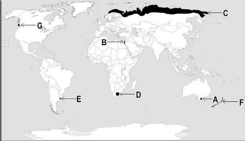
The following questions are for Visually Impaired Candidates only in lieu of Question No.29.
Answer any five questions out of the following.
a. Melbourne/Perth/Sydney
b. Tundra region of Eurasia
c. Vancouver
d. Buenos Aires
e. New Zealand
f. Suez Canal
g. Velds of South Africa
(any five to be assessed for five marks)
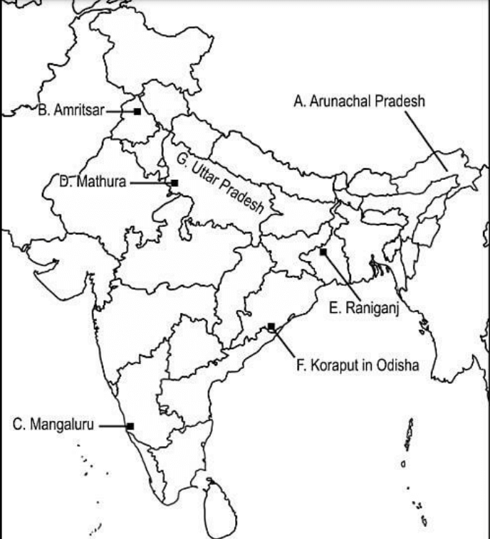
Q30.Locate and label any five of the following geographical locations on the political outline map of India with appropriate symbols.
a. the state with the lowest population density
b. an international airport in Punjab
c. an important seaport in Karnataka
d. an oil refinery in Uttar Pradesh
e. an important coal mine in West Bengal
f. Koraput – Bauxite mines
g. a state leading in the production of sugarcane
The following questions are for visually impaired students in lieu of Question No.30.
Attempt any five.
a. Name the oil refinery in Uttar Pradesh.
b. Name the international airport in Punjab.
c. Name an important seaport in Karnataka.
d. Name an important coal mine in West Bengal.
e. Name in which Koraput Bauxite mines are located.
f. Name the leader state in the production of sugarcane.
g. Name the state with the lowest population density in India.
Answer: a. Arunachal Pradesh
b. Amritsar
c. Mangaluru
d. Mathura
e. Raniganj
f. Koraput in Odisha
g. Uttar Pradesh
The following questions are for Visually Impaired Candidates only in lieu of Question No.29.
Answer any five questions out of the following.
a. Mathura
b. Amritsar
c. Mangaluru
d. Raniganj
e. Odisha
f. Uttar Pradesh
g. Arunachal Pradesh
(any five to be assessed for five marks)


 CBSE Class 12 Chemistry Additional Pract...
 CBSE Class 12 Business Studies Sample Qu...
 CBSE Class 12 Physics Model Paper 2024-2...